Chartplotters for Boats: Is It Time to Upgrade?

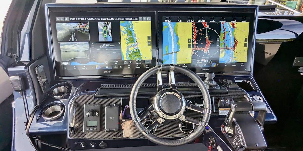
Electronics play such a big part in operating a boat that sometimes it’s easier for the captain to stare at the chartplotter instead of the water. That’s because chartplotters for boats provide real-time data and a comprehensive view of the surrounding waters. With way more detail than your eyes can take in.
The chartplotter—often incorporated into a multifunction display—integrates GPS technology with electronic charts. What you get is a detailed and interactive map that enhances situational awareness and decision-making. Top chartplotter manufacturers include Furuno, Garmin, Lowrance, Raymarine, and Simrad.
Let’s imagine a captain on a 40-foot cruising boat. For them, a chartplotter is particularly valuable because it can handle coastal navigation and open-sea voyages. The large display provides clear and detailed visuals for plotting courses, identifying hazards, and monitoring weather. The integration of radar and sonar capabilities further enhances the chartplotter’s functionality. With all of that capability, boat operators can be informed of other vessels, underwater obstacles, and changes in water depth.
Signs It May Be Time for a Chartplotter Upgrade
Like with all electronics, chartplotters for boats sometimes need to be upgraded. But how do you know? Consider the following three reasons to make the switch to a newer model.
Outdated Technology
If your current chartplotter and/or multifunction display is several years old, it might lack modern features such as touchscreen interfaces, faster processors, or improved display quality. Newer models often offer better resolution, more intuitive controls, and faster response times. That makes navigation easier and more enjoyable.
Lack of Enhanced Features
Newer chartplotters for boats come with advanced features such as integrated GPS, real-time weather updates, radar compatibility, and the ability to connect with other devices via Wi-Fi or Bluetooth. These features can improve safety and convenience while on the water.
Software and Map Updates
Older chartplotters for boats may not support the latest software updates or map data. Upgrading ensures you have access to the most current charts and navigation aids. You can reduce your risk of making errors and enhance safety.
Chartplotters for Boats Can Store and Display Navigational Data
One of the primary advantages of a chartplotter is its ability to store and display an array of navigational data. This includes waypoints, routes, and tracks, all of which can be customized and saved for future use. Being able to plan and adjust routes while cruising is invaluable, especially when dealing with changing weather conditions or unexpected obstacles.

Today’s chartplotters for boats come equipped with advanced features. One of the most valuable might be automatic route generation, which can suggest the safest and most efficient path based on current conditions.
Enhanced Integration with Onboard Systems
Another critical aspect of chartplotters is their integration with other onboard systems. Many modern chartplotters for boats can connect with autopilot systems to deliver seamless control and navigation. This integration accomplishes a couple of things. For one, it reduces the workload on the captain. In addition, it enhances safety by ensuring that the vessel stays on course even in challenging conditions.
Chartplotters can also interface with AIS (automatic identification system) to provide real-time information about nearby vessels. That information helps prevent collisions and improves situational awareness.
Features of the Latest Chartplotters for Boats
We won’t discuss every available feature in today’s chartplotters—that list is extensive—but let’s look at the most common.
High-Resolution Display
A high-resolution display is essential for clear visibility of charts and data, even in bright sunlight. This feature allows for precise navigation and easy identification of landmarks and hazards. To best use this feature, ensure the standalone chartplotter display or your MFD is positioned for optimal viewing from the helm.
Integrated GPS and AIS
The integration of GPS and AIS provides real-time positioning and tracking of nearby vessels. This feature is crucial for collision avoidance. To maximize its use, regularly monitor the AIS data and set up alerts for potential collision courses.
Radar and Sonar Capabilities
Radar and sonar integration allows captains to detect other vessels, landmasses, and underwater obstacles. This feature is particularly useful in low-visibility conditions such as fog or for nighttime cruising. To effectively use radar and sonar, familiarize yourself with the settings. Be sure to adjust the range and sensitivity based on current conditions.

Route Planning and Waypoint Management
Do you often have to plan routes and manage waypoints? Today’s chartplotters for boats can help you. Route planning and waypoint management are fundamental features. With these features, you can navigate efficiently and make easy adjustments to the course as needed. To best utilize this feature, plan your routes in advance. Consider weather forecasts and potential hazards, and regularly update waypoints based on real-time observations.
Weather Overlay and Forecasting
Many chartplotters for boats offer weather overlay features to provide real-time weather data and forecasts. Use these features to anticipate changes in weather conditions and make informed decisions about course adjustments or anchoring. You can maximize these features by checking the weather overlay regularly and setting up alerts for severe weather conditions.
Conclusions About Chartplotters for Boats
Do you need a new chartplotter? That’s up to you, obviously. Does yours still work? Then maybe you don’t need a new one. But even if it still works, does it have the latest features? Do you want those features? Might be time to look at something new.
Doug Thompson